
Drone Mapping Guide 2026: Essential Tips and Best Practices
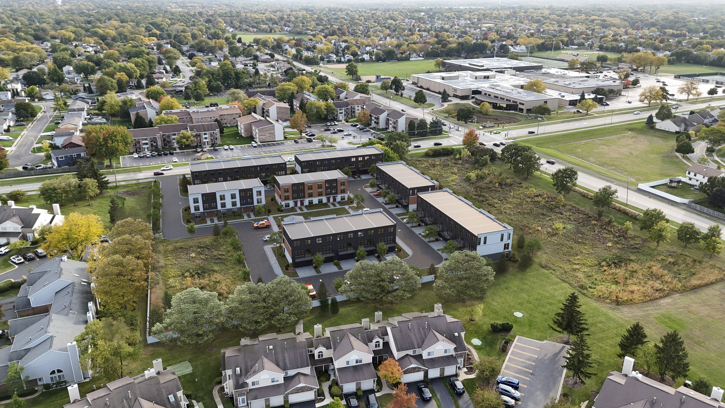
Drone image of the neighbourhood
The world is changing fast, and drone mapping is at the forefront of this transformation. In 2026, industries from construction to agriculture are harnessing these advanced tools for data-driven decisions, unlocking new levels of precision and efficiency.
This guide will walk you through the essentials, from core concepts and must-have equipment to expert workflows and the latest industry trends.
Are you ready to gain a competitive edge and master the future of mapping? Dive in to discover practical strategies and actionable tips that will empower your next project.
Understanding Drone Mapping: Fundamentals and Key Concepts
Drone mapping is transforming how professionals visualize and analyze our world. By capturing aerial data with remarkable precision, it offers a new perspective that is faster, more accessible, and often more accurate than traditional methods. As the technology advances, organizations across industries are embracing these tools to gain actionable insights and streamline workflows.
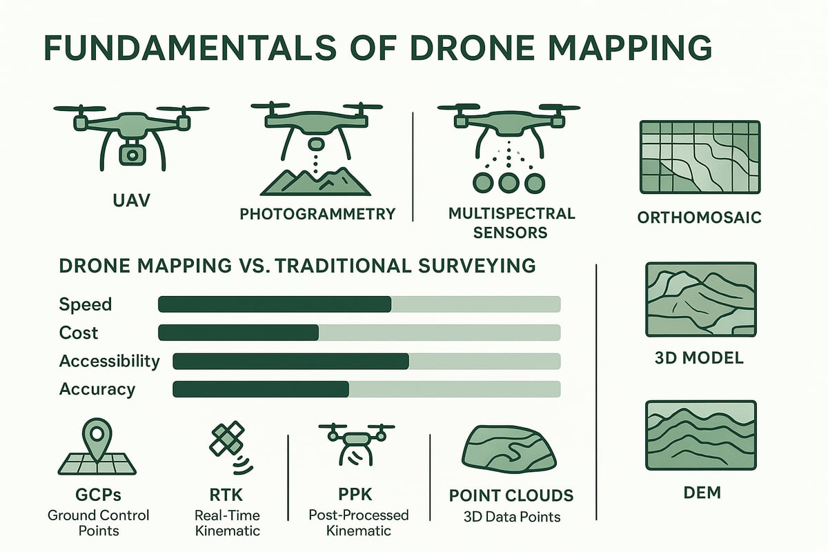
What is Drone Mapping?
Drone mapping refers to the use of unmanned aerial vehicles (UAVs) to collect high-resolution data from above, enabling the creation of detailed 2D and 3D maps and models. The core technologies behind it include photogrammetry, LiDAR, and multispectral imaging.
Key outputs generated from drone mapping are orthomosaics, digital elevation models (DEMs), 3D point clouds, and NDVI maps. Unlike traditional surveying, drone mapping delivers results in a fraction of the time, reduces costs, and makes data collection possible in areas that are difficult or dangerous to access. According to Drone Industry Insights, drone mapping is projected to remain the top application for drones worldwide.
Types of Drone Maps and Outputs
Drone mapping produces a variety of outputs tailored to different industry needs:
Orthomosaic maps: High-resolution, geo-referenced images stitched together for large-scale analysis.
3D models: Created through photogrammetry or LiDAR, offering detailed representations of terrain or structures.
DEMs, DSMs, DTMs: Digital elevation, surface, and terrain models that distinguish between ground and surface features.
Contour, volumetric, and thermal maps: Used for calculating volumes, analyzing terrain, or detecting heat signatures.
NDVI and multispectral maps: Essential for monitoring crop health and agricultural planning.
Drone Mapping vs. Traditional Methods
The advantages of drone mapping over conventional surveying methods are significant:
Feature | Drone Mapping | Traditional Surveying |
|---|---|---|
Speed | Hours | Days |
Cost | Lower | Higher |
Accessibility | Hazardous/remote areas | Limited |
Accuracy | High (with proper tools) | Comparable/Sometimes Less |
Drone mapping enables rapid data collection, slashing project timelines and operational costs. It also enhances safety by allowing mapping of hazardous or inaccessible locations remotely. With high-quality equipment, it achieves accuracy on par with, or better than, traditional surveys. The integration of drones is estimated to create over 70,000 U.S. jobs and generate $13.6 billion in economic impact, highlighting the technology’s growing influence.
Core Technologies Explained: Photogrammetry & LiDAR
Photogrammetry and LiDAR are the two primary technologies powering drone mapping. Photogrammetry involves capturing overlapping images and processing them into maps or 3D models, making it ideal for projects where visual detail is crucial. LiDAR, on the other hand, uses laser pulses to collect precise elevation data, even penetrating through dense vegetation or complex terrain.
Choosing between these technologies depends on project goals. Photogrammetry excels in visual documentation, while LiDAR is preferred for forestry management, flood modeling, and construction site monitoring. For a deeper look at LiDAR’s role in drone mapping, visit the LiDAR Scanning Services Overview.
Key Mapping Terminology
Understanding essential terminology ensures effective communication and project success in drone mapping:
GCPs (Ground Control Points): Markers on the ground with known coordinates, used to enhance map accuracy.
RTK/PPK: Real-time and post-processed kinematic GPS techniques for improved geo-referencing.
Georeferencing: Aligning data to real-world coordinates.
Point clouds: Dense sets of 3D data points representing surfaces or objects.
Accuracy metrics: Terms like RMSE (root mean square error) measure the precision of mapping outputs.
Metadata, coordinate systems, and compliance with industry standards are also critical for ensuring reliable and repeatable drone mapping results.
Essential Equipment and Software
Choosing the right tools for mapping in 2026 is crucial for achieving accurate, reliable results. The combination of advanced hardware, specialized software, and essential accessories empowers professionals to deliver high-quality outputs across industries. Let us explore the key components that form the backbone of modern drone mapping workflows.
Must-Have Drone Hardware for Mapping
Modern mapping relies on robust hardware to ensure data quality and operational efficiency. High-resolution cameras, with a minimum of 20MP, are essential for capturing detailed imagery. Sensor types such as RGB, multispectral, and thermal expand mapping applications. Reliable GNSS/GPS modules, including RTK and PPK systems, deliver the precision needed for survey-grade results.
Fixed-wing drones excel in covering expansive areas quickly, while multirotor platforms offer agility for complex sites. Battery life and range remain critical for uninterrupted missions. Gimbal stabilization ensures sharp images, reducing post-processing corrections. Selecting hardware tailored to your drone mapping needs sets the foundation for success.
Key Software for Drone Mapping in 2026
Software is the engine that transforms raw aerial data into actionable insights for your projects. Flight planning apps automate mission design, optimizing altitude, overlap, and coverage. Leading processing tools like Pix4D and Agisoft Metashape handle photogrammetry, while TerraSolid specializes in LiDAR data.
Cloud-based platforms such as DroneDeploy and Propeller Aero streamline workflows and enable real-time collaboration. Integration with BIM, GIS, and CAD systems supports diverse project requirements. Key selection factors for mapping software include compatibility with hardware, scalability for large datasets, responsive support, and overall cost.
Data Acquisition Tools and Accessories
Supporting equipment enhances both the safety and accuracy of operations. Ground Control Points (GCPs) and visible targets provide crucial ground truth for precise georeferencing. Ample high-capacity storage ensures all raw images and sensor data are securely captured during flights.
Redundant communication systems, like cellular modems or satellite links, support missions in remote areas. Weather monitoring sensors help operators anticipate and mitigate environmental risks. Safety accessories, such as parachutes and strobe lights, ensure compliance with regulations and protect valuable assets.
Selecting the Right Mapping Drone
Careful drone selection is fundamental to successful mapping. Evaluate payload capacity, flight duration, and compliance with local regulations. Popular choices include the DJI Mavic 3 Enterprise, known for versatility, the Phantom 4 RTK for high-precision mapping, and the Parrot Anafi Ai for advanced imaging.
Specialized drones equipped with LiDAR or multispectral sensors expand the range of mapping applications. Conduct a cost-benefit analysis to match drone capabilities with specific project needs. Prioritize maintenance and upgrade options to maximize equipment lifespan and ensure ongoing reliability.
Evaluating Mapping Software: Features & Comparisons
Choosing the right software for involves assessing features and compatibility. Photogrammetry software excels at generating detailed 2D and 3D outputs, while LiDAR tools handle complex terrain and vegetation. Consider cloud-based processing for scalability or desktop solutions for offline workflows.
Look for user-friendly interfaces, automation options, and robust reporting tools. Integration with business systems, such as GIS or BIM, streamlines project delivery. The table below summarizes leading options:
Software | Type | Cloud/Desktop | Key Feature |
|---|---|---|---|
Pix4DMapper | Photogrammetry | Both | Automation, reporting |
DroneDeploy | Photogrammetry | Cloud | Real-time collaboration |
Propeller Aero | Photogrammetry | Cloud | Construction focus |
Agisoft Metashape | Photogrammetry | Desktop | Customizable workflow |
The right software choice enhances every stage of the process.
The Role of 3D Visualization in Drone Mapping
3D visualization is redefining how outputs are presented to clients and stakeholders. By transforming mapping data into photo-realistic renderings and interactive walkthroughs, architects and developers can easily communicate project details. These visual tools improve project presentations, marketing materials, and client approvals.

Firms like TNT Render Studio specialize in integrating data with advanced 3D visualization services, particularly for Canadian architecture and development projects. Leveraging 3D Visualization ensures your mapping results are not only accurate but also visually compelling.
Step-by-Step Workflow: From Planning to Processing
Unlocking the full potential requires a structured, repeatable workflow. Each phase—from initial planning to final data delivery—plays a critical role in achieving reliable, high-quality results. Let us walk through every step of the process, ensuring you maximize both efficiency and accuracy in your drone mapping projects.
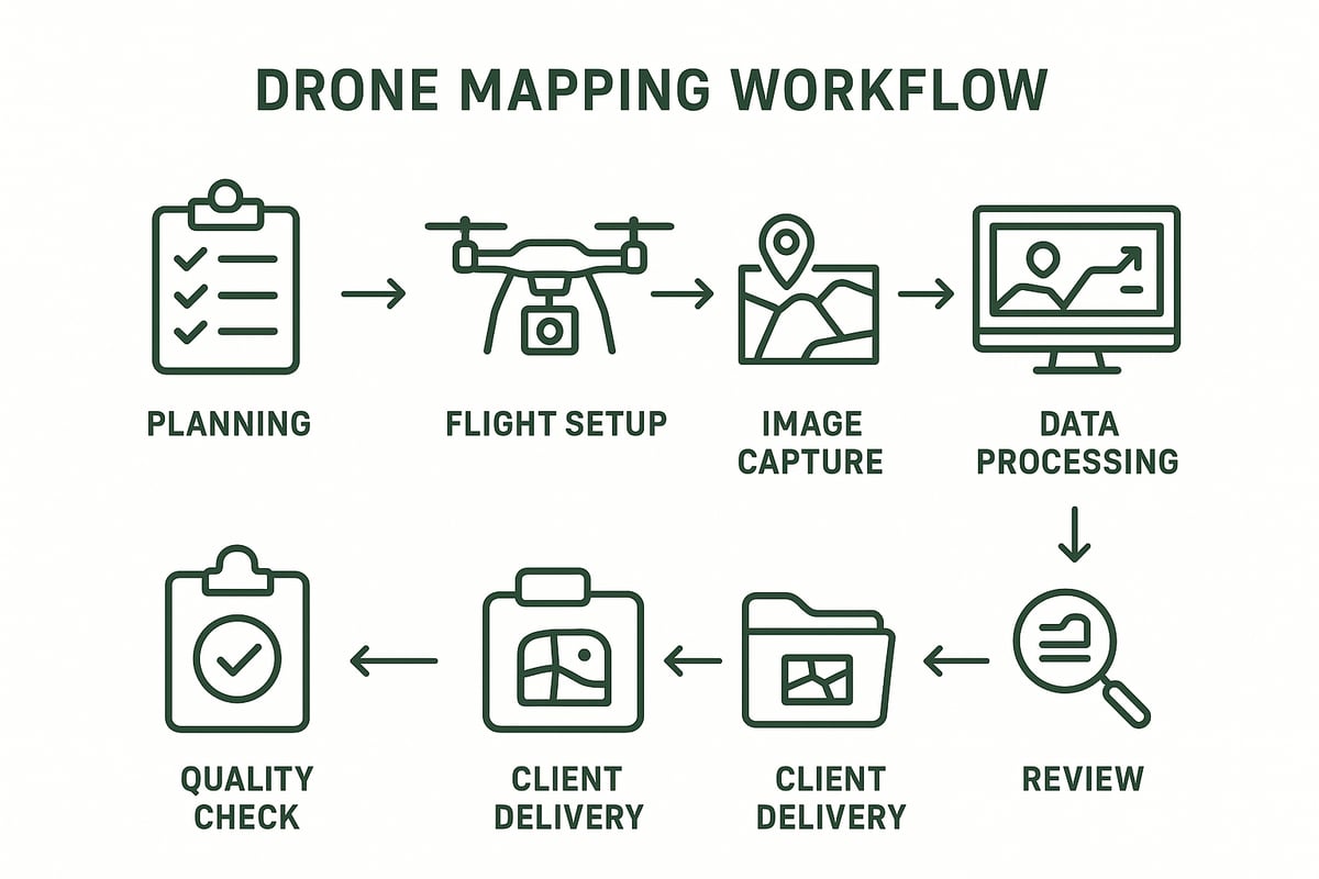
Step 1: Project Planning & Site Assessment
Effective drone mapping begins with thorough project planning. Define clear objectives and expected deliverables, such as orthomosaics, 3D models, or elevation data. Assess the site for terrain complexity, potential obstacles, and weather conditions that could impact flight safety or data quality.
Check for airspace restrictions, local regulations, and required permits. Evaluate privacy laws and coordinate with property owners or stakeholders. Conduct a risk assessment to identify potential hazards, then develop a safety plan that covers emergency procedures. Early communication with clients ensures everyone shares the same expectations for the outcomes.
Step 2: Flight Planning and Mission Setup
Select optimal flight altitude and image overlap (typically 70% front, 60% side) to guarantee data completeness. Choose the flight pattern that best fits your site, such as grid or double grid, for efficient coverage.
Set camera parameters like shutter speed, ISO, and focus to match lighting conditions. Incorporate ground control points (GCPs) and checkpoints to enhance geospatial accuracy. Complete pre-flight checklists, verify all equipment, and plan for redundancy to manage unexpected issues. Automated flight plans help ensure consistent results across your missions.
Step 3: Data Acquisition and Image Capture
During the data acquisition phase, operate the drone using autonomous or manual flight modes based on site complexity. Monitor telemetry data, battery status, and environmental factors in real time to maintain safe operations. Ensure consistent image overlap and complete coverage to prevent data gaps.
Adapt to dynamic site conditions, such as moving vehicles or changing light, by modifying flight parameters as needed. Back up captured images and metadata immediately in the field to avoid data loss. High-quality data acquisition sets the foundation for accurate deliverables.
Step 4: Data Processing and Map Generation
Once flights are complete, upload images to your chosen processing software. Generate orthomosaics, 3D models, and point clouds through photogrammetry or LiDAR workflows. Align and georeference data using GCPs to achieve precise positioning.
Perform quality assurance by reviewing outputs for gaps, blurriness, or misalignments. Export deliverables in formats like GeoTIFF, OBJ, or LAS based on client requirements. Clear documentation of each step ensures repeatability and compliance in your workflow.
Step 5: Quality Control and Accuracy Assessment
Compare processed results against GCPs and checkpoints, calculate root mean square error (RMSE), and document accuracy metrics. Troubleshoot common issues like distortion or misalignment quickly to maintain project timelines.
Adopting best practices, such as those outlined in the Top 10 mistakes to avoid in drone mapping for GIS, helps you prevent costly rework. Proper quality control not only demonstrates professionalism but also strengthens client confidence in your services.
Step 6: Deliverables and Client Communication
Prepare final maps, 3D models, and detailed reports tailored to client needs. Use visualization tools—such as interactive viewers or 3D walkthroughs—to communicate results effectively. Clearly explain findings, limitations, and recommendations to support decision-making.
Ensure secure data sharing and long-term storage of drone mapping deliverables. Request feedback from clients to identify areas for improvement and foster strong relationships. Transparent communication at this stage adds value and enhances the reputation of your drone mapping business.
Step 7: Post-Project Review and Data Management
After project completion, archive all data for future reference and regulatory compliance. Review the entire workflow to identify efficiency gains and update standard operating procedures as needed.
Maintain and calibrate equipment and software to ensure readiness for future projects. Plan for ongoing or repeat mapping missions based on client needs and site changes. Consistent post-project review supports continuous improvement in every aspect of drone mapping.
Expert Tips and Best Practices for Accurate Drone Mapping
Achieving high-accuracy results requires a strategic blend of proper planning, skilled execution, and expert data management. By following proven best practices, you can consistently deliver precise outputs and maximize the value of your projects.
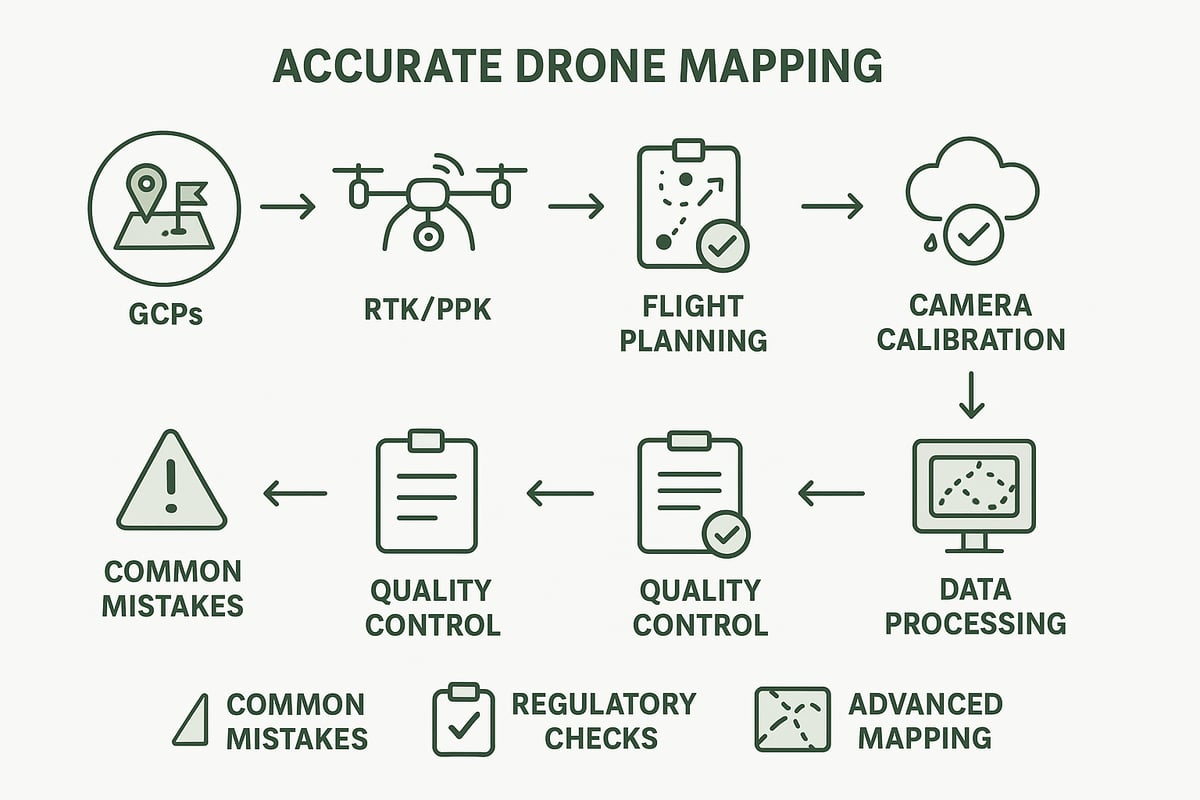
Maximizing Data Accuracy and Consistency
Accurate mapping starts with robust georeferencing. Always deploy ground control points (GCPs) and consider using drones equipped with RTK or PPK modules for enhanced positional precision. Maintain consistent flight parameters, such as optimal altitude, overlap ratios, and speed, across all missions.
Regularly calibrate your camera to prevent distortion and ensure sharp imagery. Monitor environmental factors—wind, lighting, and weather—before every flight. These variables can significantly impact mapping results.
For a deeper dive, review the Factors influencing drone mapping accuracy to understand how equipment and field conditions affect outcomes.
Optimizing Flight Planning and Execution
Begin with a comprehensive pre-flight checklist that covers hardware, software, and safety checks. Use redundant systems, such as backup batteries and communication links, for critical projects.
Adapt flight paths to match terrain complexity, and leverage automated flight planning tools to ensure complete site coverage. Real-time monitoring of telemetry and battery status lets you adjust missions as conditions change.
Efficient mapping of large fields or industrial sites is possible when you optimize flight parameters and use modern planning software, reducing both time and error rates.
Data Processing and Quality Control Insights
Processing large volumes of imagery is central. Batch processing tools streamline workflows, especially on projects with thousands of images. Automated error detection features can flag blurry or misaligned images early.
Cross-validate your outputs using field measurements and GCPs. Adhere to standardized file naming and metadata protocols for traceability. By following these steps, you ensure regulatory compliance and consistent deliverables.
Explore best practices for ensuring survey-grade data quality in drone mapping projects to further enhance your workflow.
Legal, Regulatory, and Safety Considerations
Stay updated on airspace regulations and secure all required licenses before launching any mission. Prioritize privacy and data protection, especially when operating near sensitive locations or collecting client data.
Operate within visual line of sight (VLOS) unless authorized for BVLOS operations, and ensure your team is trained for night or adverse-weather flights. Adequate insurance and liability coverage protect your business and clients.
Some regions treat unlicensed surveying as a prosecutable offense, so always confirm your activities comply with local laws.
Avoiding Common Mistakes in Drone Mapping
Overlooking image overlap or missing site areas can undermine drone mapping quality. Always double-check flight parameters and site coverage before takeoff. Ignoring weather or lighting conditions leads to unusable data.
Anticipate the hardware and software resources needed for post-processing, especially with large datasets. Validate all outputs with ground truth measurements to avoid costly re-flights and ensure accuracy.
Many issues can be prevented by thorough pre-flight checks and clear communication with your project team.
Advanced Techniques for Specialized Mapping Needs
Integrate multiple sensors—RGB, multispectral, thermal, or LiDAR—to expand the capabilities of your drone mapping. For projects demanding survey-grade precision, combine PPK/RTK workflows with well-placed GCPs.
Apply volumetric analysis for stockpile measurement, landfill tracking, or earthworks. Use change detection and time-series mapping to monitor site evolution over time.
Specialized outputs, such as NDVI for crop health or thermal maps for energy audits, showcase the versatility and power of modern drone mapping solutions.
Emerging Trends and Future Outlook for Drone Mapping
Drone mapping continues to evolve rapidly, shaping the way industries collect, analyze, and visualize spatial data. As we look to the future, several trends promise to redefine the landscape, from AI-driven automation to advanced sensors and expanding market opportunities. Understanding these shifts is vital for professionals aiming to stay ahead in drone mapping.
AI and Automation in Drone Mapping
AI and automation are transforming the industry, making workflows faster and more reliable. Automated flight planning enables drones to cover complex sites with minimal manual input, while AI algorithms process massive data sets in real time.
These intelligent systems can detect anomalies, extract features, and even deliver instant analytics to project teams. For example, automated stockpile measurements and infrastructure inspections are now possible with far less human oversight.
As AI technology matures, expect drone mapping to become even more accessible, empowering both specialists and newcomers to achieve high-quality results with less training. This shift is paving the way for unprecedented efficiency in the field.
Integration with BIM, GIS, and Digital Twins
The integration of drone mapping with BIM (Building Information Modeling), GIS (Geographic Information Systems), and digital twins is revolutionizing asset management and project collaboration. Drones deliver up-to-date spatial data, which can be seamlessly imported into BIM and GIS workflows.
This real-time data flow supports the creation and maintenance of digital twins, allowing teams to monitor, analyze, and optimize assets throughout their lifecycle. Urban planning, infrastructure monitoring, and facility management all benefit from this integrated approach.
Enhanced collaboration between field and office teams is now a reality, as drone mapping bridges the gap between physical sites and digital environments, driving smarter decision-making.
Regulatory Changes and Industry Standards
As drone mapping becomes more widespread, regulatory frameworks are evolving to ensure safety, privacy, and data integrity. Governments are updating airspace rules, introducing new certification requirements, and standardizing accuracy metrics for mapping outputs.
For professionals, staying informed about these changes is critical. Compliance with local regulations not only avoids legal issues but also guarantees the credibility of deliverables.
Industry standards are also maturing, with clear guidelines on reporting formats, accuracy thresholds, and operational procedures. The future will likely see even stricter controls and higher expectations for quality and accountability in drone mapping.
New Applications and Industry Verticals
Drone mapping is expanding into new sectors, offering solutions for environmental monitoring, disaster response, insurance, smart cities, and wildlife conservation. These applications leverage its unique strengths, such as rapid data collection and access to hazardous or remote areas.
Urban planners use it to inform development strategies, while emergency responders benefit from real-time situational awareness. Insurance professionals rely on high-resolution maps for claims assessment and risk analysis.
Site plan renders, often produced from drone data, are increasingly valuable for visualizing project layouts and communicating with stakeholders. Explore how these site plan renders for mapping projects enhance project delivery and client engagement.
Hardware and Sensor Innovations
Recent advances in drone hardware and sensors are unlocking new possibilities. Next-generation drones offer longer flight times, greater payload capacity, and higher levels of autonomy, making them ideal for large or challenging projects.
Sensor technology is also evolving, with the introduction of hyperspectral, advanced thermal, and miniaturized LiDAR systems. These innovations allow for more detailed, accurate, and versatile data collection, even in harsh or densely vegetated environments.
As these tools become more accessible and affordable, professionals can expect to tackle increasingly complex mapping challenges with confidence and precision.
Market Growth and Economic Impact
The economic impact is significant and growing. Lowering costs and improved accessibility are driving adoption across industries, creating new job opportunities and business models.
According to recent projections, the drone mapping market is expected to reach $6.7 billion by 2035. This surge is fueled by demand for faster, more accurate data and the expanding range of applications.
With over 100,000 jobs anticipated and billions in economic impact, the outlook remains strong. Professionals and businesses that embrace these trends will be well-positioned to thrive in this dynamic landscape.
As you explore the essential tips and best practices, you’ll see how the right blend of technology and expertise can elevate your project outcomes. Whether you’re an architect, developer, or homeowner, integrating high-quality 3D visualization with accurate drone data opens new doors for impactful presentations and confident decision-making. If you’re ready to take your next project to the next level or have questions about the best approach for your needs, I invite you to Contact Us for expert guidance and tailored solutions.